 |
| 3800 kilometers in two circle tours |
28 December 2010
Where we've been
We have now traveled about 3800 kilometers and haven't left the state of Victoria which is relatively small. We don't feel like we've seen anywhere enough of Victoria yet! A year isn't long enough!!!!
26 December 2010
Wonder where that road goes?
15 December 2010
As planned we left Melbourne yesterday but decided to head south and east toward Wilson's Promontory National Park.
We had a nice time in Melbourne visiting with Greg, Chrissy and JAM. We got most of our errands done and restocked Bunyip. Trox got his new bike and we got some things fixed. In addition we had a nice time celebrating my birthday. We went to a small restaurant and had great pasta and then we went to see Harry Potter on the IMAX screen. But as we left Melbourne we were glad to put the hustle and bustle (not to mention the traffic) behind us. And last night as we fixed dinner we both were glad to be "home".
We managed to make it to the campground at Wilson's Prom and as we drove the length of the park we both commented on how few people were in the park - like NONE. Then we got to the campground. O.M.G. PEOPLE! There are about 500 campsites and probably 400 were occupied - many by MANY people. The powered sites were packed with as many tents and trailers as people could get in one site. I can't say I blame people since the powered sites are more than $50/night. The other sites were also often crowded but we found one that was comfortably close to the bathrooms and relatively isolated.
This morning we got up and Trox went for a ride. Unfortunately no bikes are allowed on any of the trails - not even on the maintenance roads.Once he was back we packed up and headed back north out of the park. On the way we stopped at the car park for Mt. Oberon where we had breakfast and then hiked up to the top.
We started at an elevation of 225 meters and the top was 3.4 kilometers away and 552 meters high. So in about 3 miles we gained about 1000 feet of elevation. It wasn't really steep but very definitely constantly up hill. At the "top" we had to climb a steep narrow set of steps up the last 100 feet or so. The steps were cut into the granite with a few places of wood steps built over the granite. There were occasional guard rails. The view was worth the climb although I was wishing Tom was along with his harness and rope to help with the climb back down. Once back at Bunyip we continued down the road to Squeaky Beach. What a beautiful beach.
The sand is white quartz and supposedly squeaks when you walk on it. No squeaks today - probably because all the sand was wet - it's rainy. There are lots of granite boulders helter skelter on the beach.
Right now we are at the terminus of Five Mile road. No idea why it's called Five Mile. It isn't 5 miles long and besides distance is measured here in kilometers. There are lots of Banksia trees here which are mostly out of bloom. What is left are most impressive.
We are also seeing Australian Grass trees. These leave behind a stalk after they bloom. They remind us of Yucca. They tend to bloom after a fire and there is obvious signs of fire in this area. Some of these plants can be several hundred years old and can grow many meters high.
OH! OH! AN EMU! Too far away for a picture but neat none the less as he ran across the road.
We have now left the park and are looking for a campsite. Looks like we will stay at Shallow Inlet Reserve Campground which is just out of the park and down a dirt road. Trox is now exploring with the "ranger" - an older gentleman who came out to greet us. He obviously is in charge and lives in a 50s era trailer. We are just a stone's throw from the water. I'm not sure if this is private or government run.
17 December
What a wonderful day we had yesterday. Started by getting up late and then paying for another night at this campground. Ends up it is owned and operated by the "greenies" - a branch/office of the government and is "Crown owned land". It is tucked at the end of a dirt road and has lots of sites cut out of the heavy undergrowth. Many sites are private and most sites are sheltered from the wind. The ranger was very helpful and gave us lots of information. We had a very nice double site to ourselves with the trail to the beach close by and the "dunny" just across the road. We had to look dunny up in our slang book where it is listed as "a lavatory". Once we were sorted we took off for the park and breakfast. We drove out to the car park at the end of Five Mile Rd. Had breakfast and then headed out on a hike. The first part of the loop ended at Miller's Landing - a shallow rock strewn beach with a sizeable stand of Mangrove trees and some weird shaped/colored granite boulders.
The return loop had a spur up to a lookout. Trox took the spur and I continued back to Bunyip where I was able to park my chair in the shade and read while waiting for the wandering unit. The weather was sunny but not hot and was very pleasant. Trox spotted some interesting flora and fauna on his spur.
From there we headed to Whisky Bay where Trox took the bike for a spin along the road and a short trail. Once he was back we headed down to the water where we found a pretty white sand beach. Both ends of the beach had large granite boulder outcroppings. The surf was up and very rough but Trox went in anyway although not far as he said the current was very strong.
After that it was time to find a place for dinner. We ended up parked in a small lot right on the main road but up high with a beautiful view of the ocean to the west so we could watch the sunset over the water.
My pictures of the sunset came out prettier than the real thing - aren't filters a wonderful thing? Once dinner and sunset were enjoyed we headed for our campsite. On the way to our camp we learned first hand why after dark driving is discouraged. Lots (as in LOTS) of Roos and a few Wombats and bunnies and a fox all popped out to say "howdy" but we made it back with no mishaps.
18 December
Yesterday we got up and headed further east and north - hmmmm wonder where this road goes - seemed to be the theme of the day. Someone had recommended we be sure to see Agnes Falls
and since it was close that's where we headed for breakfast - WELL worth the side trip.
Too bad the sign said NO CAMPING because it would have been a wonderful place to spend a night or two.
Within site of the falls area was a large wind farm that someone else had told us about.
After breakfast Trox said let's take some of the back roads - oh goody! The GPS directed us up this nice paved road to a little town - well really just a crossroad where the pavement ended. We were in a beautiful forest with huge tree ferns, pines, gums, mountain ash and what looked to be some kind of cedar. The trees called Snow in Summer were in bloom and gorgeous. And the GREEN! WOW! When we would break out of the heavy forest as far as we could see was lush velvet green with large rolling hills. Lots of dairy cows and we passed a Llama farm (ranch?) as well as spotting some deer. DEER? What are they doing here? Trox says they are raised for their meat although ends up there are feral deer in this area also and people are allowed to stalk (hunt) them. We also saw lots of evidence that the area is being logged but luckily didn't see any logging trucks. Found out a little later that the logging is to salvage timber burned in the big fire a few years back. After many kilometers (maybe 60) and a few hours we finally found pavement once again. We stopped in Traralgon to get diesel, a little food and water then pressed on a little further to a state park (Holey Plains) where we spent the night. It looked to be a place where Trox could ride but the rain drove us out this morning.
We are currently sitting in a nice park in Sale ("Sal") having breakfast studying maps. Which way to go? North? East?
19 December
Well east it was right up until we saw a road to the north that said it led to a National Park so north we turned. By that time it was late afternoon so we were looking for a place to stay. We found a road that said it went to the park and so we took it - sure enough we found a really nice place with trails to walk and tracks to ride and a big NO CAMPING sign - well shit! BUT there was a map that showed how to get to some camp areas. We picked one and headed out. After 17K of dirt (metal) windy, twisty, hilly road (oh, my favorite - not!) we came to the end of the road into a beautiful meadow full of roos. It was the camp area with dunnys and barbies and only one other camper. It is along the Mitchell River and the camp area must be 50 acres or so.
It has been cloudy and sunny and rainy and foggy (sometimes all at once) since we got here and was delightfully cool for sleeping last night. Trox got up and did a nice ride early this morning starting out in a fog and returning in rain. Tomorrow or the next day is the first day of summer and I keep thanking what/whoever that it has stayed cool so long. Our plan at this point is to say here at least one more night and maybe more. We are within striking distance of Melbourne although it would be a very hard day's drive so we will probably leave here no later than the 24th - probably earlier. We'll see how the water and battery holds up. Oh, yes, while we were driving around we spotted a flock (mob? herd? gaggle?) of Emu. They are a rather majestic bird but very skittish.
23 December
I have been bad about writing to my journal so need to catch up. I try to keep the book I am using in my lap in the truck as we drive along but had managed to leave it in the back a few days ago. We ended up spending three nights at Mitchell River area
and were alone except for the one other camper.
Even out in the hinterlands Australia is effecient. These toilets are CLEAN and don't even really smell even though they are pit toilets that have to be pumped out.
The greenish tank on the back is to capture rain water and even though there is no potable water in the area at least there is water. These tanks are everywhere and if there are no roofs to capture the rain water they build a "roof" a few inches off the ground to capture water. The park/forest service in the US could take some lessons!
On Monday the ranger showed up as well as a tractor with a mower. The grass was about knee deep and had gone to seed. The ranger said the Roos like the heads and it is a summer grass (uh, means it grows in the warm weather) so they never mow until close to Christmas. Tuesday morning we were able to watch three small (joys? wallabies?) Roos playing and boxing in the mowed area. Lots of little lizards were around but would never hold still long enough to examine closely. Trox said some of them are blue. The dragon flies on the other hand are everywhere and they stay still for a LITTLE while.
It rained and cleared on and off our whole time there and it was fun to watch the storms blow in and out. Trox managed to get a few rides in between and during the rains.
When we left we headed north towards Dargo. There the woman assured us we could get through to the Great Alpine Highway if we didn't mind windy, gravel mountain road for about 50 kilometers. Us? Mind?
Just outside of Dargo we found a place for brunch and had a nice break before heading further up into the mountains.
We got to the Grant Historical Park and according to a brochure we had there was plenty of camping there so we turned in. This is an old gold mining area with two ghost town sites; Grant and Talbotville. We missed the camp area at Grant (we found it next day) and ended up on a ridge with a small park area and a table and a VIEW
and NO signs saying we couldn't stay the night. Just a few meters further down the road was a sign saying CAUTION WINDY STEEP NARROW 2-WHEEL DRIVE ROAD. Neither of us (especially me) thought it would be a good idea to proceed.
That was our planned story if a ranger came along. We had a nice walk and were early enough that Trox decided to ride before dinner. And what a ride! I'll get him to write about it. He ended up riding UP the road we decided to not drive DOWN. He reported that we could have made it down but it would have required valium and warm milk on my part.
Next day we went for a few short walks one included walking through the cemetery at Grant - a now very defunct gold mine town. The cemetery is maintained by a 4x4 group in the area and has nice trails and graves marked with small rock outlines and a few headstones with little iron fences.
And on down the road towards the Great Alpine Highway heading for Mt. Buffalo National Park. We stopped in Bright where the info center assured us we could find a campsite in the park. Bright is a cute little tourist town and probably a very trendy place to visit. We moved on and found that campsite.
And that catches us up to the 23rd. That was last night. What a beautiful park. This morning we got up and broke camp then drove to the Horn. From the car park we did the relatively short but STEEP hike up to the top.
From there the views were spectacular.
We had our breakfast before leaving the area and then headed back down to the Chalet area where we did a short walk out to see a water fall and some overlooks.
The trails here are well marked, well maintained but a few more guard/hand rails would be nice.
We then went exploring around the Chalet which was built in 1910
and appears to be only open in the winter. It has beautiful little gardens built around the big granite boulders.
The rhododendrons and azaleas were still pretty and must have been amazing a few weeks ago.
We are currently on our way down the mountain and sitting at a light used to control traffic through an area where the road USED to be. It obviously washed out during the recent flooding.
We did find out that the fire that did all the extensive damage in this park was in 1985. There is also extensive fire damage from the past few years.
We stopped at the car park for the Eurobin falls and did the "short" walk to the falls. 750 meters of stairs cut into the granite. The first falls is the "Ladies Bath Falls" and on our way up there were 3 young adults playing in the natural pool at the base of the falls.
The next look out was the Lower Eurobin and then the upper.
Lots of water going over the side of that mountain!
On the way back down the trail Mr. Unit decided to try the Ladies' Bath.
Anyone surprised?
And now we are back on the road heading for Nug Nug. We would have liked to stay in the area longer but Melbourne calls.
We are going to see if we can possibly get reservations for around the 1st of the year but will be shocked. School holidays have already started and after the 26th the hordes will descend.
24 December
Spent the night at a Nug Nug Reserve. A nice green shady place with lots of space but also lots of people. Trox got a nice ride in on the local dirt roads and we now are on the road heading for Eildon and then Melbourne on Christmas.
I got a little too much sun yesterday but it felt SOOOOOO good. Today I have slathered on the sun block.
We were heading for Whitfield via dirt roads that we were assured were good and passable - WELLLL - I think we made a wrong turn some where - after a few kilometers on a seldom used one lane track (I refuse to call it a road) Trox parked us and took out on foot to find a place to turn around. He found a place and came back to get me and Bunyip and proceeded another kilometer or so where he turned us around and back out to the "main road". So, back safely on a 1.5 to 2 lane kinda gravelled road we headed once again for Whitfield. As we approached a little town named Cheshut we found where the track would have come out - looks like it follows a power line up and over the mountain in the Black Forest. Shortly after that we came to a sign that said "Paradise Falls that-a-way" so once again we made a detour. This one about 10 or 15 K each way. The falls were well worth the side trip and a great place for brunch.
We did finally make it to Whitfield and on. We are currently parked at Power's lookout which was another detour that someone at Nug Nug said not to miss. It is a beautiful spot and no one here but us units. Power was some bandit in the 1800s who used this as a hide-out. Nice overlooks and Trox made a short hike.
We are trying to decide if we should stay - there is no sign that says we can't camp and I think we could find a flat spot. We are about 170K from Melbourne.
Later
Unfortunately upon further inspection of the route plotted by the GPS that 170K would take us a few days on dirt roads up and over here and there. We were actually more like 250K so we continued on down the road. We found a really nice little day use area clearly posted NO CAMPING!! but a nice fisherman directed us into the Rubicon State Forest and said there would be plenty of spaces. There were!
25 December
Christmas morning dawned bright and cold with a fresh layer of snow covering the meadow on the other side of the river - NOT! Actually Christmas morning was high overcast and cool (60s F mid-teens C). Trox got up for an early morning ride and I luxuriated in bed for another 20 minutes or so. We stayed in a camp ground along the Rubicon River last night and although we couldn't see the river we could hear it. It was a very short walk to the water. It is a very pretty river with small rapids in between smooth flowing sections. Once back from his ride he helped to break camp and we headed down the road to the nice day use area we had spotted yesterday. That's where we are now - watching birds; eating breakfast; and preparing for the reentry into Melbourne.
As we have driven through this area the past few days the flood damage is every where. This is one that 40 or 50 years from now the "old timers" will say, "Well, I remember the great flood of '10".
Oh! Oh! Unit just spotted a road with a sign that says "turn here for ... ". I guess we'll be a little later than expected into Melbourne.
We took a side trip up into Cathedral State Park - very pretty with a nice camp area but now we are back on the highway. Stopped at a pretty overlook for lunch and a break and then back on the road again.
The forest we are driving through is beautiful with lots of very tall gums and as ground cover gorgeous tree ferns which are about 10 feet high. The road is a good road albeit windy and no shoulder. There isn't much traffic but more than I expected on Christmas. Looks like everyone is going OUT of Melbourne as we work our way in.
Now we are about 30K from Greg & Chrissy's and we heard a whump, whump, whump ... looked at each other and said "oh, shit, what's that sound" ... yup we have another flat ... I WANT NEW TIRES!
Merry Christmas, everyone! And may all of you and yours have a safe and healthy New Year!
As planned we left Melbourne yesterday but decided to head south and east toward Wilson's Promontory National Park.
We had a nice time in Melbourne visiting with Greg, Chrissy and JAM. We got most of our errands done and restocked Bunyip. Trox got his new bike and we got some things fixed. In addition we had a nice time celebrating my birthday. We went to a small restaurant and had great pasta and then we went to see Harry Potter on the IMAX screen. But as we left Melbourne we were glad to put the hustle and bustle (not to mention the traffic) behind us. And last night as we fixed dinner we both were glad to be "home".
We managed to make it to the campground at Wilson's Prom and as we drove the length of the park we both commented on how few people were in the park - like NONE. Then we got to the campground. O.M.G. PEOPLE! There are about 500 campsites and probably 400 were occupied - many by MANY people. The powered sites were packed with as many tents and trailers as people could get in one site. I can't say I blame people since the powered sites are more than $50/night. The other sites were also often crowded but we found one that was comfortably close to the bathrooms and relatively isolated.
This morning we got up and Trox went for a ride. Unfortunately no bikes are allowed on any of the trails - not even on the maintenance roads.Once he was back we packed up and headed back north out of the park. On the way we stopped at the car park for Mt. Oberon where we had breakfast and then hiked up to the top.
 |
| the view from the top |
 |
| lots of little to medium sized islands |
 |
| it was windy |
 |
| chilly and wet |
 |
| beautiful sand and BIG boulders |
 |
| these blooms are huge - some about 12 inches |
 |
| what's left after the grass trees bloom |
We have now left the park and are looking for a campsite. Looks like we will stay at Shallow Inlet Reserve Campground which is just out of the park and down a dirt road. Trox is now exploring with the "ranger" - an older gentleman who came out to greet us. He obviously is in charge and lives in a 50s era trailer. We are just a stone's throw from the water. I'm not sure if this is private or government run.
17 December
What a wonderful day we had yesterday. Started by getting up late and then paying for another night at this campground. Ends up it is owned and operated by the "greenies" - a branch/office of the government and is "Crown owned land". It is tucked at the end of a dirt road and has lots of sites cut out of the heavy undergrowth. Many sites are private and most sites are sheltered from the wind. The ranger was very helpful and gave us lots of information. We had a very nice double site to ourselves with the trail to the beach close by and the "dunny" just across the road. We had to look dunny up in our slang book where it is listed as "a lavatory". Once we were sorted we took off for the park and breakfast. We drove out to the car park at the end of Five Mile Rd. Had breakfast and then headed out on a hike. The first part of the loop ended at Miller's Landing - a shallow rock strewn beach with a sizeable stand of Mangrove trees and some weird shaped/colored granite boulders.
 |
| Mangroves make for muddy beaches |
 |
| cool rock |
 |
| an insect |
 |
| a lizard? legs? |
 |
| definitely a lizard |
 |
| pretty flowers |
After that it was time to find a place for dinner. We ended up parked in a small lot right on the main road but up high with a beautiful view of the ocean to the west so we could watch the sunset over the water.
 |
| fixing dinner at sunset |
 |
| two large ships (tankers) passing by on the horizon |
 |
| sunset |
18 December
Yesterday we got up and headed further east and north - hmmmm wonder where this road goes - seemed to be the theme of the day. Someone had recommended we be sure to see Agnes Falls
 |
| top part of falls |
 |
| The Units at the overlook |
 |
| humpf! |
 |
| Bunyip |
 |
| nearby wind farm |
We are currently sitting in a nice park in Sale ("Sal") having breakfast studying maps. Which way to go? North? East?
 |
| a nice place for breakfast |
19 December
Well east it was right up until we saw a road to the north that said it led to a National Park so north we turned. By that time it was late afternoon so we were looking for a place to stay. We found a road that said it went to the park and so we took it - sure enough we found a really nice place with trails to walk and tracks to ride and a big NO CAMPING sign - well shit! BUT there was a map that showed how to get to some camp areas. We picked one and headed out. After 17K of dirt (metal) windy, twisty, hilly road (oh, my favorite - not!) we came to the end of the road into a beautiful meadow full of roos. It was the camp area with dunnys and barbies and only one other camper. It is along the Mitchell River and the camp area must be 50 acres or so.
 |
| wide open area |
 |
| our view |
 |
| there were about 6 or 7 Emus |
23 December
I have been bad about writing to my journal so need to catch up. I try to keep the book I am using in my lap in the truck as we drive along but had managed to leave it in the back a few days ago. We ended up spending three nights at Mitchell River area
 |
| flattest spot we found was on a "track" |
 |
| pretty shrubs and very high grass |
 |
| the loo or dunny |
On Monday the ranger showed up as well as a tractor with a mower. The grass was about knee deep and had gone to seed. The ranger said the Roos like the heads and it is a summer grass (uh, means it grows in the warm weather) so they never mow until close to Christmas. Tuesday morning we were able to watch three small (joys? wallabies?) Roos playing and boxing in the mowed area. Lots of little lizards were around but would never hold still long enough to examine closely. Trox said some of them are blue. The dragon flies on the other hand are everywhere and they stay still for a LITTLE while.
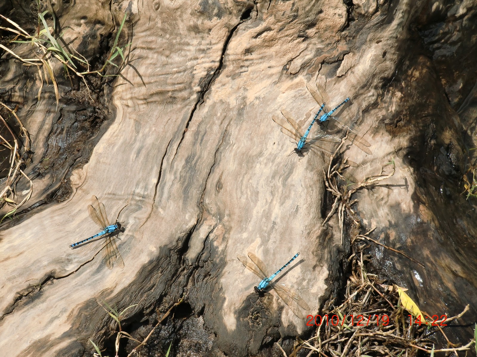 |
| dragon flies bite! |
 |
| it is raining outside! |
 |
| flowers spotted in Dargo |
 |
| brunch spot |
 |
| outside our back window |
 |
| our dining table |
 |
| the good part of the road |
 |
| breakfast time again |
 |
| nice identified grave |
And that catches us up to the 23rd. That was last night. What a beautiful park. This morning we got up and broke camp then drove to the Horn. From the car park we did the relatively short but STEEP hike up to the top.
 |
| up there's the top |
 |
| at least this part had rails but who needed them at this point? |
 |
| that's the "highway" up |
 |
| views are pretty spectacular |
 |
| The wildflowers seem to grow right out of the granite |
 |
| part of a waterfall yes, it keeps going down that DROP |
 |
| at least they have rails at the outlook spots |
 |
| the Chalet |
 |
| an English garden |
We are currently on our way down the mountain and sitting at a light used to control traffic through an area where the road USED to be. It obviously washed out during the recent flooding.
We did find out that the fire that did all the extensive damage in this park was in 1985. There is also extensive fire damage from the past few years.
We stopped at the car park for the Eurobin falls and did the "short" walk to the falls. 750 meters of stairs cut into the granite. The first falls is the "Ladies Bath Falls" and on our way up there were 3 young adults playing in the natural pool at the base of the falls.
 |
| Ladies Bath Falls |
 |
| Lower Eurobin Falls |
 |
| The top! Finally! Upper Eurobin Falls |
 |
| getting ready to get in |
 |
| frolicking |
We are going to see if we can possibly get reservations for around the 1st of the year but will be shocked. School holidays have already started and after the 26th the hordes will descend.
24 December
Spent the night at a Nug Nug Reserve. A nice green shady place with lots of space but also lots of people. Trox got a nice ride in on the local dirt roads and we now are on the road heading for Eildon and then Melbourne on Christmas.
I got a little too much sun yesterday but it felt SOOOOOO good. Today I have slathered on the sun block.
We were heading for Whitfield via dirt roads that we were assured were good and passable - WELLLL - I think we made a wrong turn some where - after a few kilometers on a seldom used one lane track (I refuse to call it a road) Trox parked us and took out on foot to find a place to turn around. He found a place and came back to get me and Bunyip and proceeded another kilometer or so where he turned us around and back out to the "main road". So, back safely on a 1.5 to 2 lane kinda gravelled road we headed once again for Whitfield. As we approached a little town named Cheshut we found where the track would have come out - looks like it follows a power line up and over the mountain in the Black Forest. Shortly after that we came to a sign that said "Paradise Falls that-a-way" so once again we made a detour. This one about 10 or 15 K each way. The falls were well worth the side trip and a great place for brunch.
 |
| two separate falls from the same creek |
 |
| a man from Melbourne took our pic |
 |
| one of my favorite past times |
Later
Unfortunately upon further inspection of the route plotted by the GPS that 170K would take us a few days on dirt roads up and over here and there. We were actually more like 250K so we continued on down the road. We found a really nice little day use area clearly posted NO CAMPING!! but a nice fisherman directed us into the Rubicon State Forest and said there would be plenty of spaces. There were!
25 December
Christmas morning dawned bright and cold with a fresh layer of snow covering the meadow on the other side of the river - NOT! Actually Christmas morning was high overcast and cool (60s F mid-teens C). Trox got up for an early morning ride and I luxuriated in bed for another 20 minutes or so. We stayed in a camp ground along the Rubicon River last night and although we couldn't see the river we could hear it. It was a very short walk to the water. It is a very pretty river with small rapids in between smooth flowing sections. Once back from his ride he helped to break camp and we headed down the road to the nice day use area we had spotted yesterday. That's where we are now - watching birds; eating breakfast; and preparing for the reentry into Melbourne.
As we have driven through this area the past few days the flood damage is every where. This is one that 40 or 50 years from now the "old timers" will say, "Well, I remember the great flood of '10".
 |
| damaged bridge still under new temp bridge |
 |
| you can see where the flood wiped out some fencing also |
 |
| along the Rubicon |
We took a side trip up into Cathedral State Park - very pretty with a nice camp area but now we are back on the highway. Stopped at a pretty overlook for lunch and a break and then back on the road again.
The forest we are driving through is beautiful with lots of very tall gums and as ground cover gorgeous tree ferns which are about 10 feet high. The road is a good road albeit windy and no shoulder. There isn't much traffic but more than I expected on Christmas. Looks like everyone is going OUT of Melbourne as we work our way in.
Now we are about 30K from Greg & Chrissy's and we heard a whump, whump, whump ... looked at each other and said "oh, shit, what's that sound" ... yup we have another flat ... I WANT NEW TIRES!
Merry Christmas, everyone! And may all of you and yours have a safe and healthy New Year!
 |
| Pretty Flowers For Christmas |
Subscribe to:
Posts (Atom)